


The weather is the state of the atmosphere with refference to wind, temperature, state of the sea, cloudiness, precipitation, atmospheric pressure, humidity, mist, fog, ice conditions.
It is important for seaman to understand all phenomena conected with the weather and to be able to read weather maps and listen to the weather forecast and report weather conditions at sea such as visibility and the direction of wind and its force according Beaufort Wind Scale.
Winds
Winds are mainly caused by a difference of temperature which in turn is sometimes responsible for the differences of barometric pressure. The strength and speed of wind at any given time depend on the gradient of atmospheric pressure that is the rate at which pressure changes with distance.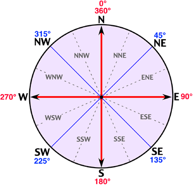
Speed of movement of pressure systems
Slowly: Moving at less than 15 knots
Steadily: Moving at 15 to 25 knots
Rather quickly: Moving at 25 to 35 knots
Rapidly: Moving at 35 to 45 knots
Very rapidly: Moving at more than 45 knots
Timing of gale warnings
Imminent: Within 6 hours of time of issue
Soon: Within 6 - 12 hours of time of issue
Later: More than 12 hours from time of issue
Terms referring to wind:
Backing - Indicates the changing of wind in the anticlockwise direction (i.e. from W to SW)
Becoming cyclonic - Indicates that there will be considerable changes in wind direction across the path of a depression within the forecast area.
Wind direction - Indicates the direction from which the wind is blowing.
Veering - Indicates the changing of the wind in a clockwise direction (i.e. from SW to W)
Variable - Indicates the wind constantly changing the direction from which it blows.

Why are ice classes needed?
the Ship Classification Societies "ice class" has a fundamental basis on the safety of the ship hull and the essential propulsion machinery. The class defines sufficient installed power for a safe operation in ice covered waters. The classification also defines certain hull structure against certain level ice, which in the Baltic Sea conditions is defined using the first year ice definition. The classifications also defines the requirements for the propeller shaft as a minimum power for maintaining ship speed in a re-frozen (covered by e.g. brash ice) fairway navigation channel.
When the ice conditions became difficult, traffic restricions are imposed. The restrictions pertain to the availability of icebreaker assistance. Some of the restrictions are about safety independent of assistance standards; some are caused by the availability of icebreaker services. The traffic restrictions are based on Ice Class Rules.
Ice Navigation
The Baltic Sea freezes anually.
The two most heavily marine operated areas in the world where seasonal sea ice plays an important role in navigation are the Gulf of St. Lawrence in Canada and the Baltic Sea in Europe. In the Baltic Sea aproximetely 40 percent of the total amount of cargo turnover, about 700 milion tons, occurs during winter months. Tha Baltic Sea freezes anually and in some parts the ice season lasts up to 7 months, from November to May. For example, in the Gulf of Finland the average length of the ice season is 120 days outside St. Petersburg, and 30 days at the entrance of the gulf.
The ice conditions are mostly affected by two factors: the number of sub-zero days and the prevailing winds. The sum of sub-zero degree-days controls the ice growth and the amount of ice. The prevailing winds control drifting and ridging of an ice field.
Forming of an ice cover
An ice cover starts to form on water when the surfer temperature reaches freezing point. Fresh water freezes at 0 C and in sea water freezing point decreses with increasingly salinity. Thus freezing point in ocean water is about -1.8C, but in the brackish water of the Baltic Sea it is about -0.4C.
In the Gulf of Finland ice thickness is greatest in the eastern parts of the gulf and is about 50 cm in an average winter. The biggest obstacles to winter navigation are ridges which are normally thicker than the level ice and are difficult to penetrate. Channels with thick side ridges and thick brash ice in the middle are formed when the ice cover in the fairway is repeatedly broken and frozen. The side ridges make passing of other vessels very difficult. The keel heights of the ridges are normally a lot bigger than the sail heights. The side ridges may grow several metres thick and the brash ice layer in between may become up to one metre thick. Ridges also form when winds push ice together.
In the Baltic Sea area ice conditions are monitored on a daily basis. The Finnish Ice Service of the Institute of Marine Research issues ice charts and ice reports and produces ice drift forecasts. The daily ice chart and ice report include a description of current ice conditions and information about the icebreakers operational areas.